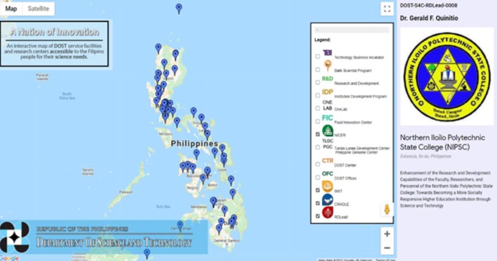
The Philippine interactive map of the Department of Science and Technology (DOST) plots service facilities and research centers accessible to Filipinos for their science needs.
The DOST Innovation Landscape Map was developed to showcase the reach of the various projects and programs of the DOST and its attached agencies.
The map presents information in an interactive geographical format, which allows users to quickly see the areas in the country covered or reached by the various DOST offices, projects, programs, and initiatives.
The DOST Innovation Landscape Map showing the reach of the 4 component programs of the Science for Change Program (S4CP) namely: NICER, CRADLE, BIST, and RDLEAD.
Initially published in 2019, it now includes 13 different DOST-funded projects and programs of the DOST and its attached agencies.
These programs are the following:
1) Technology Business Incubator (TBI)
2) Balik Scientist Program (BSP)
3) Research and Development (R&D)
4) Institution Development Program (IDP)
5) OneLab
6) Food Innovation Center (FIC)
7) Tuklas Lunas Development Center (TLDC) – Philippine Genome Center (PGC)
8) DOST Centers
9) DOST Offices
10) Niche Centers in the Regions (NICER)
11) Business Innovation through Science and Technology (BIST)
12) Collaborative R&D to Leverage the Philippine Economy (CRADLE) and the 13) Research and Development Leadership Program (RDLead)
Users have the option to choose which projects or programs to focus on by selecting from the list. Once they click on the location pin on the map, they will be provided with basic information about the program or project located in the area chosen.
For the newly added RD Lead Program, users will be able to see the institution assisted, the RD Leader engaged, as well as the title of the capacity-development program.
The RDLead Program is a capacity development program of the DOST under the S4CP which aims to enhance the human research capital in the country. It serves higher education institutions (HEIs), Research and Development Institutes (RDIs), and National Government Agencies (NGAs) to develop and enhance their research capabilities. It started in July 2018 and is implemented by the National Research Council of the Philippines (NRCP).
Phivolcs has also mapped the Philippines’ earthquake-prone areas and natural hazards while Google Maps now updates the country’s COVID-19 cases.
CHECK OUT the Philippine interactive map for science services accessible to Filipinos in this link.
Good News Pilipinas is celebrating its 15th Anniversary in 2021 by giving away prizes! Subscribe to our Good News Pilipinas! TV YouTube channel and enter the raffle by sending us an email to editor@goodnewspilipinas.com

