BBC News features record-breaking auction for Philippines “Holy Grail” map disputing China’s territorial claims
By: Angie Quadra-Balibay
|
Published on: September 29, 2019

The Murillo Velarde map published in 1734 is cited as the first scientific map of the Philippines and considered the most important Philippines map. Credits to Reeman Dansie.
The auction for the “Holy Grail” map of the Philippines made BBC News headlines after the collectors item fetched a record-breaking £260,000 from a phone bidder.
The Reeman Dansie Auction house notes on Lot 790 offered on the Antiques and Fine Art Sale on September 25, 2019 said “the map was instrumental in the Philippines’ efforts to assert territorial rights in the South China Sea” and was used “to refute China’s historic claim of ownership of the entire South China Sea”. The 2016 Permanent Court of Arbitration ruled in favor of the Philippines.
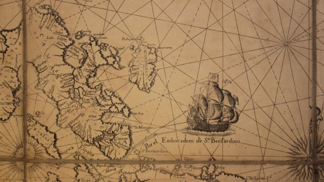
The Philippines’ map includes the ‘Panacot’ (Scarborough Shoal) as well as ‘Los Bajos de Paragua’ (Spratly Isles).
It is cited as the first scientific map of the Philippines and considered the most important Philippines map.
The Murillo Velarde Map map was drawn by Pedro de Murillo Velarde (1696-1753), engraved by Nicolás de la Cruz Bagay, and published in Manila in 1734 with the title Carte Hydrografica Y Chorographica de la Yslas Filipinas.

The Holy Grail map includes the ship Victoria. Credits to Reeman Dansie.
BBC News notes that the sale price was the highest for a single lot in the 138-year history of Reeman Dansie Auctions in Essex.
The 300-year-old map is one of the 15 surviving copies of the Murillo Velarde map of the Philippines made in 1734.
“For collectors in this niche field, this map is the Holy Grail,” auctioneer Daniel Wright was quoted in the report.
“There’s only 15 known copies and most of them are in institutions such as the British Museum, so for one to come to market is very unusual,” added Wright.
The Philippines map, from the collection of the late Christopher Beresford-Jones, was auctioned in a full salesroom with over 800 online bidders from around the world.

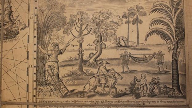
The Philippines inhabitants and resources were fully annotated on the 1734 map. Credits to Reeman Dansie.
The Philippines was Spain’s colony when the Murillo Velarde map was drawn in the 1700s. The map was drawn on paper, mounted on linen, and measures over 1 square meter.
The features of the Murillo Velarde map include the following:
- detailing of the Philippine islands
- shipping routes for trade with China
- drawings of the archipelago’s inhabitants and natural resources
- brief history of the archipelago starting with Ferdinand Magellan’s arrival and death in 1521
- engraving of Murillo Velarde’s ship, the Victoria
- different ethnic groups, customs, flora, and fauna
- miniature maps of Guajan (Guam), Manila, Samboangan, and Cavite
- description of the settlements, peoples, clergy, and administration
The map was created for navigation but was also used “to promote the Philippines’ resources to its Spanish colonial rulers”, reports BBC News.
The Holy Grail map is known to have influenced subsequent maps of both the Philippines and European maps.
In 2021, the Philippines is marking the 500th year anniversary of the first circumnavigation of the world by Ferdinand Magellan and the victory of Lapu-Lapu in the Battle of Mactan. Preparations for the Quincentennial celebrations are on the upswing with museum tours and heritage church reopenings, among others.
TELL US in the comments below your thoughts on the Murillo Velarde map?
Like, Follow, Subscribe to GoodNewsPilipinas.com Facebook, Twitter, Instagram, Good News Pilipinas! TV on YouTube, new story notifications and e-mail newsletters for updates on more Filipino Pride stories.
