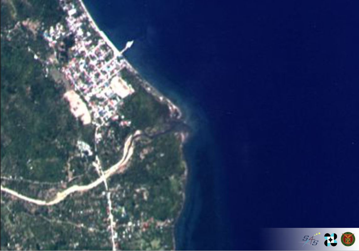
Unreleased photos from Diwata-1 and Diwata-2 scientific Earth observation microsatellites of the Philippines were posted for the first time to mark Earth Day 2020.
The STAMINA4Space / PHL-Microsat Facebook page released the 10 images of various countries captured by the Philippines’ first and second microsatellites. The microsatellites were developed by a team of scientists from the University of the Philippines and the Department of Science and Technology.
“We know we can’t go out to enjoy our pale blue dot’s beautiful landscapes and seascapes at the moment, so we bring you some images captured by our Diwata-1 and Diwata-2 scientific Earth observation microsatellites.📡🛰
“While the Philippines is the priority of our missions, we can also capture images of other parts of the world. Here, we share some previously unreleased images so that we can simultaneously bask in our planet’s beauty, and reflect on how we can better care for it,” STAMINA4Space / PHL-Microsat posted on Facebook on April 22, 2020.
The photos were accompanied by captions of the location, satellite, date of capture, and the sensors used in capturing the images of earth as seen from space.
The Philipines’ image of Cajidiocan, Romblon was captured by Diwata-2 on June 4, 2019, using High Precision Telescope (HPT).
“In this image, we can see where the Cambajao river mouth meets the Sibuyan Sea. It also shows diverse areas: a high built-up area, vegetated land and apparent underwater features,” STAMINA4Space / PHL-Microsat posted.
Here are the other 9 images from the Philippines’ microsats:

Area captured: Kesrouane, Lebanon
Satellite: Diwata-2
Date of Capture: March 19, 2019
Sensor: High Precision Telescope (HPT)
“The interesting land features in this town are called Kesrouane formations, which took shape as early as the Jurassic era. These formations are due to underground water movement.”
Area captured: Rakalj, Croatia
Satellite: Diwata-2
Date of Capture: August 5, 2019
Sensor: High Precision Telescope (HPT)
“The capability of satellites to monitor maritime activities was demonstrated as Diwata-2 captured ships (appearing as white caps) exiting the ria of Raški zaljev.”
Area captured: Dubai, United Arab Emirates
Satellite: Diwata-2
Date of Capture: March 9, 2019
Sensor: High-Precision Telescope
Captured in this image is a commercial center in Dubai consisting of banks and malls around a mosque. Individual structures can be identified due to the high resolution of the sensor.

Area captured: Aegina, Greece
Satellite: Diwata-2
Date of Capture: July 21, 2019
Sensor: High Precision Telescope (HPT)
Aegina hails from Greek mythology and is the mother of the hero Aeacus. Nowadays, the island is known for its pistachios.
Area captured: Güvemalanı, Turkey
Satellite: Diwata-2
Date of Capture: July 19, 2019
Sensor: High Precision Telescope (HPT)
Here, we see croplands nearly approaching the Turkish shoreline.PH
Area captured: Queensland, Australia
Satellite: Diwata-2
Date of Capture: January 6, 2020
Sensor: Spaceborne Multispectral Imager (SMI)
A mix of land and water surface features are visible. Shallow areas are visible through the turquoise waters near the shore.

Area captured: Kantubek, Uzbekistan
Satellite: Diwata-1
Date of Capture: September 6, 2016
Sensor: Middle Field Camera (MFC)
Kantubek is a town in Vozrozhdeniya Island in the Aral Sea which used to be the island’s administrative center.
Area captured: Southern Patagonia Ice Fields, Argentina
Satellite: Diwata-1
Date of Capture: September 10, 2016
Sensor: Middle Field Camera (MFC)
The Southern Patagonian Ice Fields are located in the Southern Patagonic Andes between Chile and Argentina. It is the largest temperate ice sheet in the Southern Hemisphere.
Area captured: Lake Drummond, Virginia (USA)
Satellite: Diwata-1
Date of Capture: October 25, 2016
Sensor: Middle Field Camera (MFC)
Lake Drummond, a freshwater lake at the center and highest point of the Great Dismal Swamp National Wildlife Refuge in Virginia, is visible as a dark blue spot near the center of the image.
Diwata 1’s space mission was recently completed after four years and has re-entered the Earth’s atmosphere.
Diwata 1, the Philippines’ first microsatellite, was launched on March 22 (March 23 PH time) 2016 from Cape Canaveral Air Force Station in Florida.
DIWATA-1, successfully captured its first images from space orbit during initial checks of the onboard components and has received praises for capturing world-best high-resolution images during its test phase.
The direct launch into orbit of Diwata-2, the second Philippine microsatellite developed by Filipino scientists, was streamed live on October 29, 2018, via YouTube from the Japan space center.
SEND CHEERS in the comments below to the teams behind Diwata-1 and 2 for capturing the beauty of the earth and sharing these on Earth Day 2020.
Want to know how to be a Proud Pinoy? Like, Follow, Subscribe to GoodNewsPilipinas.com and our socials Facebook, Twitter, Instagram, Good News Pilipinas! TV on YouTube, for new story notifications and e-mail newsletters for updates on more Filipino Pride stories.


